Saturday, June 27, 2009

Angkor Wat

Angkor Wat

Noted for its architectural and artistic perfection, not to mention its sheer size, Angkor Vat is the most famous and no doubt the most remarkable of all of Cambodia's ancient temples. Combining great technical mastery on an unprecedented scale with extraordinary architectural and artistic innovations, Angkor Vat has a unique place in the long ancient Khmer tradition of the royal "Temple-Mountain.". Built in the 12th century in the reign of King Suryavarman II, this was the residence of Vishnu, the divine palace in which the King himself was to reside after death. The construction is thought to have taken some thirty years of intensive labor.

In the "Middle Period", notably in the 16th century, Angkor Vat, then known as Preah Pisnulok (the posthumous name of its royal founder), became a site of Buddhist pilgrimage not only for the Khmer people but for much of Southeast Asia, and indeed for other more distant Asian peoples. Today, the Khmer people see in "Little Angkor" (the familiar name of Angkor Vat), the symbol of their nation.


Angkor Wat, forming a rectangle of about 1,500 by 1,300 metres, covers an area including its 190 metre wide moats - of nearly 200 hectares. The external enclosure wall defines an expanse of 1,025 metres by 800, or 82 hectares. It is the largest monument of the Angkor group.


Constructed to the south of the capital (Angkor Thom), Angkor Vat is sited in the southeast corner of the ancient city of Yashodhara built by Yashovarman I and centred on Phnom Bakheng.

The westward orientation of Angkor Vat is opposite to the orientation of sanctuaries dedicated to divinities. In Brahmanic funerary rituals, the rites are performed in reverse of the normal order - the ritual procession does not follow "pradakshina" (keeping the monument to one's right), but rather in the opposite direction, the "prasavya?". Hence, the bas-reliefs are to be viewed in an anti-clockwise direction.


Angkor Wat Plan Site


The moats surrounding the external enclosure of the monument are bordered by steps with a moulded sandstone perimeter, and are five and a half kilometres in overall length.

They are crossed only at two places - to the east by a simple bank of earth, and to the west by a 200 metre-long and 12 metre-wide sandstone-paved causeway, lined with columns along its sides. A cruciform terrace decorated with lions, precedes this causeway and is bordered by naga balustrades.


The temple enclosure, formed by a high laterite wall incorporates a colonnade of 235 metres composed of a three-part gopura - the towers of which are cruciform in plan and galleries that link with two pavilions at either extremity which served as passageways for elephants.


Kuk Ta Reach

Kuk Ta Reach, the "Sanctuary of the Royal Ancestor" is the traditional name of the series of porticos in this colonnade leading into the interior of Angkor Vat. Of the many divinities and spirits worshipped here, 'Ta Reach' is by far the most important. Embodied in a colossal four-armed statue worshipped in the portico to the south of the main entrance, Ta Reach's protective powers are known throughout the Angkor region. Over the past decades, local caretakers have restored parts of the Ta
Bas-Relief Galleries Reach statue with cement. In 2003, the cement replica head was replaced by the original that had been stored for safekeeping at the National Museum of Cambodia.


The bas-reliefs cover the inner walls of the galleries of the lower enclosure and comprise of panels two metres in height with a total area of more than 1,000 square metres excluding the corner pavilions. Limited to the zone that would have been accessible to the public, they represent legendary and historic scenes for the enlightenment of the faithful.

These galleries, which are open to the exterior and form the temple's third enclosure wall, are sculpted in bas-reliefs representing historical and epic scenes. The friezes were, for the most part, executed during, or shortly after, the reign of Suryavarman II. Only the northeastern corner - the northern section of the eastern gallery and the eastern section of the northern gallery were left bare at that time, to be sculpted later, in the 16th century. These late reliefs are notably inferior in quality of conception and execution, due most probably to a rupture in the artistic tradition between the fall of the capital at Angkor in the 15th century and the 16th-century restoration. The scenes represented are as follows:

1. The Battle of Kurukshetra, between the Pandava and the Kaurava families, from the Mahabharata epic tale.The reliefs sculpted on the southern section of this western gallery represent a concluding episode of the Mahabharata, a renowned Indian epic tale.This is the Battle of Kurukshetra, when the Pandava and Kaurava clans meet in final, deadly combat. Interestingly, the Mahabharata is virtually unknown in modern Cambodia. Unlike the Ramayana, which continues to permeate all aspects of Khmer culture, the Mahabharata would seem to have faded from cultural practice and memory with the decline of the Angkorian Empire.

2. Historical scenes depicting the reign of Suryavarman II.
The reliefs sculpted on the western section of this southern gallery commemorate a series of historical events from the reign of King Suryavarman II, the founder of Angkor Vat in the 12th century. As the brief inscription
engraved next to the image of Suryavarman II identifies this king by his posthumous name, Paramavisnuloka, the reliefs themselves are thought to have been sculpted shortly after his death.

Hell

3. Heavens and Hells: the consequences of one's acts can be pondered as the blessed delight in celestial bliss above while the wicked suffer in agony below.
The reliefs sculpted on the eastern section of this southern gallery represent the 37 Heavens and 32 Hells derived from Indian tradition. The Hells, on the lower registers, are pictured in greater detail than the Heavens above. Each Hell is in fact identified by an accompanying inscription. Thus we read "Avici", "Raurava", etc., names still known and feared in Cambodia.

4. "The Churning of the Sea of Milk".
The reliefs sculpted on the southern section of this eastern gallery represent the "Churning of the Sea of Milk", a popular episode from Vishnu lore. The Gods (northern part) and the Demons (southern part) use the serpent Vasuki as a cord wound around Mount Mandara, emerging from the Sea; pulling alternately on either end of the serpent, together they churn the Sea of Milk in order to extract the nectar of immortality. Seizing the nectar as it is formed, the Gods are victorious, and thus thereafter immortal.


5. Victory of Vishnu over the Asura demons. The reliefs on this northeastern corner (northern section of the eastern gallery and eastern section of the northern gallery) were sculpted in the 16th century, some four hundred years after the original construction of Angkor Vat and the sculpture of most of the temple's gallery walls. These reliefs clearly demonstrate that, though Cambodia had by then become a Theravadin Buddhist nation, the Khmers had not yet forgotten their past Brahmanic culture. The scenes on the northern section of the eastern gallery, are thought to have been extracted from the Indian Harivamsa, show the God Vishnu, in the center, singularly defeating the Demons.

6. Victory of Krishna (an avatar of Vishnu) over the demon Bana.
The scenes on the eastern section of the northern gallery, thought to have been extracted from the Indian Harivamsa, show Krishna, one of Vishnu's many avatars, defeating his rival Bana. A variety of Gods are represented here, including Shiva at the western end.

7. Combat between the Gods and the Demons.
All the major Brahmanic Gods, identifiable by the attributes they brandish and the animal mounts they ride, are represented on the western portion of this northern gallery. Each God is shown in singular combat with a Demon. In a similar way to other sculpted galleries of Angkor Vat, the God Vishnu, pictured here in the center of the long panel, is pre-eminent.

8. The Battle of Lanka, from the Ramayana epic tale.
The reliefs of the northern portion of this western gallery illustrate a renowned episode of the Ramayana, the Indian epic tale which recounts the exploits of Prince Rama (an avatar of Vishnu). We see here the Battle of Lanka, in which Rama's monkey army led by the monkey General Hanuman fights the Demon King Ravana's army. Rama's army seeks to rescue his wife Sita, who has been captured and held hostage in Lanka, Ravana's island kingdom.
Preah Paon

The name of this cruciform gallery - 'the Thousand Buddhas' - dates from the Middle Period, when the prestige of Angkor Vat spread across Buddhist Asia. Over the course of time the faithful erected here a great number of statues of the Buddha in stone, wood or metal, hence the gallery's name. Some of the statues still remain while


others are exhibited or kept in conservation storehouses. Others have, for diverse reasons, been lost forever. Together, these Buddhist statues testify to an artistic school unique to the temple of Angkor Vat.
The majority of Angkor Vat's 41 inscriptions dating from the Middle Period are found here, on the pillars of Preah Poan. Largely in Khmer, sometimes including Pali phrases, they date from the 16th to 18th centuries and record pious works performed at Preah Pisnulok by pilgrims, including members of the royal family. The authors inscribe their "vows of truth" and declare their "pure faith" in the religion of the Buddha. These stone inscriptions make an invaluable contribution to our understanding of the ideology of Theravada Buddhism as it became Cambodia's principal and official religion. Inscriptions in other languages, such as Burmese and Japanese, further demonstrate the cross-cultural attraction the temple has long exerted.

Bakan

Originally the principal sanctuary of Angkor Vat's uppermost terrace was open to the four cardinal points, and probably sheltered a statue of Vishnu, the supreme god of the temple. Later, when Angkor Vat became a center of Buddhist pilgrimage, the four entranceways into the central sanctuary were filled in with sandstone blocks; each of the newly constituted walls was then sculpted with a deep relief of the standing Buddha. In 1908 archaeologists opened the southern entranceway. In the place of any original Vishnu statue, they found multiple statue and pedestal fragments, as well as a sarcophagus. Further research carried out in the well of the central sanctuary in the 1930s revealed, at a depth of 23 meters, the temple's original foundation deposits: two circular gold leaves embedded in a laterite block.

A number of inscriptions at Preah Poan and Bakan, along with the artistic style of these Buddha figures, indicate that the enclosure of the central tower and its transformation into a Buddhist sanctuary was a royal work executed in the latter half of the 16th century. This architectural and iconographic transformation translated into space the conceptual transformation of the central Brahmanic sanctuary into a Buddhist stupa. Here the four Buddhas of the past, facing each of the four cardinal points, surround the garbha - the maternal matrix - which encloses Maitreya, the Buddha of the future. The Bakan illustrates in a most spectacular manner the evolution of Angkor Vat over time: as the ancient Vishnuite temple became a sacred Theravadin Buddhist site, Angkor Vat undoubtedly played a primary role in the conversion of Cambodia into a Theravadin nation.
Angkor Vat Today

Angkor Vat has always figured on Cambodia's national flag. The temple symbolizes the soul of the Khmer people, and the lasting grandeur of their past.

Since December 1992, Angkor Vat and other Angkorian monuments have been classed as UNESCO "World Heritage". This is a great honor for Cambodia, and a major national obligation. We are responsible for Angkor's preservation not only before history and in respect of our ancestors, but also, today, before the entire international community.

Friday, June 26, 2009

Cambodia's Water Festival

Water Festival (Bun Oumtouk)

The Tonle Sap or "Great Lake" as it's called is more than just a body of water giving life to Cambodia and Southeast Asia. The Tonle Sap represents a people's identity and way of life for the thousands of Cambodians who call the riverbanks home. These people float in boats that are both homes and businesses along the muddy waters day in and day out. And they give to the water as it gives to them.

The Tonle Sap is one of the most fish abundant lakes in the world and the silt deposits left behind by the annual floods have created fertile ground for agriculture. It's no surprise that one of Asia's greatest ancient civilizations developed near this lake and today much of Cambodia's livelihood still depends on its output. So dependent are Cambodians that the government vigorously enforces fishing bans from March to November. Many people depend on the Tonle Sap and its ebbs and flows to maintain life and everyone in Southeast Asia recognizes this fact of life.

Along the banks of the Tonle Sap, people have celebrated the river's gifts for centuries. People celebrate its change of flow and welcome the swelling banks that bring in good fortune for families of fishermen. During the rainy season the Tonle Sap reverses direction, flooding the lake, increasing its size almost tenfold, making it the largest freshwater body in Southeast Asia. And the people along the banks of the Tonle Sap find good reason to celebrate their Great Lake and take joy in its natural changes. The Tonle Sap is the only waterway in the world that flows in opposite directions at different times of the year. Once an arm of the sea, the Tonle Sap is a true natural phenomenon.

One of the largest festivals of Cambodia revolves around the Tonle Sap. The three-day Water festival of the reversal of the waters of the Great Lake is celebrated in October or November depending on when the waters reverse and flow back into the Mekong River. Boat races, the largest part of the festival, are held at the capital, Phnom Penh. Each village has the opportunity to join in the boat races and usually they do. The boats are usually dugout canoes with a prow and stern that curve upward. The boats are elaborately decorated and carved to represent the village. The prow is painted with a large eye like those that decorated the war vessels of ancient times.

A boat can have as many as 40 rowers. Pairs of boats race each other for the first two days. A race including all the canoes takes place on the last day of the festival. The purpose of this race is to make the god of the river happy so that there will be many fish and the rice crop will be plentiful. The Water festival, while celebrating the reversal of the waters, also marks the beginning of the year's fishing season.

Up to a million people from all walks of life and from all over the country flock to the banks of the Tonle Sap to watch the boat races and to celebrate the Tonle Sap. With the city filled to full-capacity at this time, it's no surprise that it takes on a carnival air and feeling felt by everyone. Live concerts are held, food stands are set up, and children and adults alike take rides on ferris wheels to celebrate the joy; at night, fireworks light up the sky and people dance in the street. People from the countryside throughout Cambodia come to the festival, many traveling down the three rivers that run through the city. Some come to race their long, hand-carved boats. Others come to see the three days of boat races and take part in the festivities or to take advantage of the many things for sale. This is Cambodia's version of Mardi Gras and many throughout the world look forward to attending just the same.

Just like at Mardi Gras, the crowds at the Water festival are huge. To contain thousands of festival-goers, police barricades stop motorized traffic, letting only bikes and people on foot through. Because it is a festival, school is canceled and many workers are off work. This large crowd of people fills the streets of the city within ten blocks of the Tonle Sap and the Royal Palace and the city explodes with excitement.

The Water festival also coincides with the full moon of the Buddhist calendar month of Kadeuk. The Cambodians believe that the full moon is a good omen which promises a bountiful harvest. On this night, people gather to give thanks to the moon and to pray for the upcoming season. Special food is prepared for this occasion that includes fruits, vegetables and Ambok-a Cambodian specialty. Worshippers light candles and burn incest while offerings are given. The chief priest lights the candles and as it drips on the banana leaves spread beneath the candles, predictions are made. Cambodians believe that the shape of the melted wax created on the leaves, predicts the harvest of the coming year. But whatever the prediction, it does not dampen the spirit of the Water festival and people excitedly look forward to the upcoming fishing season and giving thanks to the ever-nourishing waters of the Tonle Sap

Khmer Heritage

THE KHMER EMPIRE

The Khmer Empire was at its apogee during the reign of Jayavarman VII (1181-1215 A.D.). Its territory covered the current Cambodia, all of southern Vietnam, all of the current Laos, all of the current Thailand, and part of the current Malaysia. Unlike the Khmers, Thais, known then as Siameses, were not natives of the region. The kingdom of Thailand, known then as Siam, did not appear in Southeast Asia until the mid- 14th century.

A well-known Thai historian, Sulak Sivarak, who was a Nobel Peace Prize nominee and the winner of the Right Livelihood Award said of the Khmer Empire: "It included everything right up to Lopburi and all of what is now Bangkok". Again, describing the Khmer Empire, Peter Janssan of the Hindustan Times quoted Sulak Sivaraka in his article on 18 June 2008: "Thai invasions of Cambodia, then in its decline, led to the adoption of many Khmer cultural traditions by the Thais, including the Hindu concept of god-kings and court rituals, and an ongoing fondness for Brahman-inspired black magic, especially among Thai politicians". Peter Janssan went on to describe that there are many more Khmer temples located in Thailand, especially along the northeast Thailand- Cambodian border like Buriram, Surin, and Sisaket. The map depicting the Khmer Empire at its height is shown in Figure 1.

Khmer Empire during the Height of its Civilization, Before the Appearance of Siam (From Jayavarman II to Jayavarman VII)
Figure 1. Khmer Empire during the Height of its Civilization, Before the Appearance of Siam (From Jayavarman II to Jayavarman VII)

THE FRENCH PROTECTORATE

Cambodia was a vassal state under Siam during the reign of King Ang Duong. Cambodia had lost Battambang, Sisophon, and Siem Reap to Siam. Siam had placed spies everywhere at the court of Oudong. To get out of the Siam’s manacles, King Norodom who succeeded his father, King Ang Duong, sought out help from France. On 23 March 1907, under the reign of King Sisowath who succeeded his brother, King Norodom, France (as the protectorate of Cambodia) and Siam signed a border treaty that completed the 1904 treaty. In the 1904 treaty Siam ceded Tonlé Repou, Mlou Prey, Koh Kong, and Stung Trèng to Cambodia. The 1907 treaty subsequently produced the French- Siamese Commission 1907 Frontier Line (Figure 2), placing Preah Vihear under the control of Cambodia. The French-Siamese 1907 treaty had Siam ceded almost all Cambodia ancient territory of the 16th century back to Cambodia. The territory included Battambang, Sisophon, Siem Reap, Mongkol Borei, and Tnot (Figures 3 and 4).

Extract from the International Court of Justice Report 1962 – The French-Siamese Commission 1907 (Scale 1:200,000) (Courtesy Bora Touch. Note in blue added by Bora Touch for clarity)
Figure 2. Extract from the International Court of Justice Report 1962 – The French-Siamese Commission 1907 (Scale 1:200,000) (Courtesy Bora Touch. Note in blue added by Bora Touch for clarity)

Map of Cambodia Showing the Te rritory That Siam Ceded To France in 1907
Figure 3. Map of Cambodia Showing the Te rritory That Siam Ceded To France in 1907

Map of Present Day Cambodia Courtesy: Official Map by the Royal Government of Cambodia Submitted to UNESCO for Preah VihearWorld Heritage List
Figure 4. Map of Present Day Cambodia Courtesy: Official Map by the Royal Government of Cambodia Submitted to UNESCO for Preah VihearWorld Heritage List

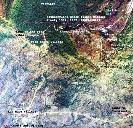
In spite of this agreement, Thailand contested in 1934 that the Temple of Preah Vihear belonged to her and their surveyors redrew the frontier to locate Preah Vihear in Thailand’s territory. In 1954 Thailand occupied Preah Vihear. On 6 October 1959, Cambodia, under the leadership of Prince Norodom Sihanouk, petitioned the International Court of Justice (ICJ) of the Hague, Netherlands, to rule on the dispute. By the end of the year, Thailand retaliated with a claim listing Preah Vihear as a national archeological site. On June 15, 1962, the ICJ made a judgment recognizing that the Temple of Preah Vihear belonged to Cambodia using the French-Siamese Commission 1907 Frontier Line as one of the supporting arguments (Figure 5). A satellite photo showing Preah Vihear and its surrounding region with demarcations of the frontier established by the French-Siamese Commission 1907 is presented in Figure 6. Figure 7 shows another satellite photo of Preah Vihear and the Dangrek mountain range. Thailand never protested against the verdict. However, over the years Thailand has unilaterally redrawn the map that contradicts the ICJ judgment (Figures 8- 10).

Area of the Temple of Preah Vihear in the Dangrek Range of Mountains (Extrapolation from the map recognized by the International Court of Justice, 15 June 1962) Courtesy: Official Map by the Royal Government of Cambodia submitted to UNESCO for Preah VihearWorld Heritage List
Figure 5. Area of the Temple of Preah Vihear in the Dangrek Range of Mountains (Extrapolation from the map recognized by the International Court of Justice, 15 June 1962) Courtesy: Official Map by the Royal Government of Cambodia submitted to UNESCO for Preah VihearWorld Heritage List

Satellite Photo of Preah Vihear and its Surrounding Region (Courtesy: Bora Touch)
Figure 6. Satellite Photo of Preah Vihear and its Surrounding Region (Courtesy: Bora Touch)

Satellite Photo of Preah Vihear and its Surrounding Region (Courtesy: Bora Touch)
Figure 7. Satellite Photo of Preah Vihear and its Surrounding Region (Courtesy: Bora Touch)

Thai Internal Working Document – The Official Thai Map (Scale 1:10,000) Courtesy Bora Touch. Notes in blue and green Colors added by Bora Touch for clarity
Figure 8. Thai Internal Working Document – The Official Thai Map (Scale 1:10,000) Courtesy Bora Touch. Notes in blue and green Colors added by Bora Touch for clarity

Thai Internal Working Document – The French-Siamese Commission Map Made in 1907 (Scale: 1:200,000) (Courtesy Bora Touch. Notes in blue by Bora Touch for clarity)
Figure 9. Thai Internal Working Document – The French-Siamese Commission Map Made in 1907 (Scale: 1:200,000) (Courtesy Bora Touch. Notes in blue by Bora Touch for clarity)

Extract from the Aide Memoire of Cambodia Royal Government 1962 (Scale: 1:6,000) (Courtesy Bora Touch. Note in blue by Bora Touch for Clarity)
Figure 10. Extract from the Aide Memoire of Cambodia Royal Government 1962 (Scale: 1:6,000) (Courtesy Bora Touch. Note in blue by Bora Touch for Clarity)

The temple of Preah Vihear was originally built under Yasovarman I, a Khmer king who reigned from 889 to 910 A.D. The building started in light material, but its completion in stone was carried on later by his successors. The temple was dedicated to Shiva (God of destroyer).

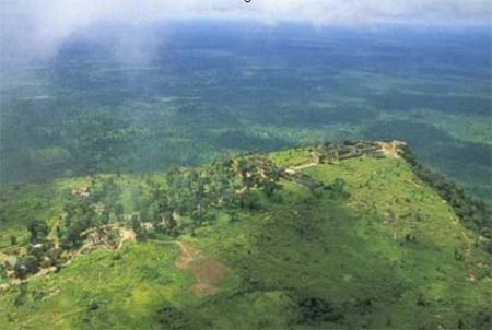
The setting of Preah Vihear was ideal for a Khmer monarch who dedicated the temple for Shiva because of its spectacular location sitting atop of a high cliff over 500 meters above the lower ground. Aerial views of the Preah Vihear temples are shown in Figures 11 and 12.

Aerial View of Preah Vihear Hanging Over a Cliff On Cambodia Territory (Courtesy: Official Photo by the Royal Government of Cambodia Submitted to UNESCO for Preah VihearWorld Heritage List)
Figure 11. Aerial View of Preah Vihear Hanging Over a Cliff On Cambodia Territory (Courtesy: Official Photo by the Royal Government of Cambodia Submitted to UNESCO for Preah VihearWorld Heritage List)

Aerial View of Preah Vihear
Figure 12. Aerial View of Preah Vihear

THE THAI TWISTED THESIS OF THEIR ORIGIN

There are some Thais in the academic, the press, and the media who fantasize in their justification of Preah Vihear belonging to Thailand by advancing a twisted thesis claiming that Khmer is not the same as Khorm (note: the Thai used to call Khmer as either Khamin or Khorm). They say that Khmer is Khamin, which is different from Khorm. Furthermore, they say that Khorms are the real inhabitants of what is now Thailand and they were the builders of Preah Vihear, Angkor, and all the ancient temples found in Cambodia and Thailand. They are saying that Khmers are not the descendents of the Angkor builders. Therefore, they try to justify by implication that Thai people are the true descendents of the Khorms, the original inhabitants of Thailand and builders of Preah Vihear and Angkor. The Thai people have such a twisted mind. Believing in this twisted thesis is like believing that a bullet firing from a gun can be curved around a corner. The Thais are not only satisfied to steal everything that are precious to Khmers and then claimed them to be their own, such as Preah Ko Preah Keo, Preah Khan Reach, Khmer classical dance and music, Khmer style boxing, and Khmer scripts “Aksor Moul” (the Thai called it sacred scripts instead of Khmer scripts), but now they try to even steal Khmer identity. They want to strip Khmer people bare of any ancestry.

OBSERVATIONS

A few important observations to the central issue of the Preah Vihear temple must be brought up to the attention of the world. The following are two immediate points of interest concerning the affair of the Preah Vihear temples:

  1. The press keeps mentioning that Preah Vihear was an ancient Hindu temple instead of a Khmer temple. Preah Vihear is not a Hindu temple but a Khmer temple built under the reign of Yasovarman I, a Khmer king in the 9th century, dedicated to Shiva, one of the Hindu gods. When the press says that Preah Vihear is a Hindu temple, it deemphasizes Khmer ownership and legitimacy to the temple. In modern time, the war of words is very important. This clarification is very important and it must be emphasized at all time.
  2. Thailand kept insisting on using her own map to claim the disputed area around Preah Vihear instead of the French-Siamese Commissioned Map of 1907, where the International Court of Justice (ICJ) based its judgment on to award Preah Vihear to Cambodia. The map was the product of the treaty signed by Thailand and French (Cambodia was under the French protectorate) in 1907. It is legal and binding. Thailand wants to use its own map that is not binding and not recognized by the International Court of Justice. Cambodia must not give in to the Thai insistence of using her own map to settle the dispute of Preah Vihear and its surrounding area.

CONCLUSION

Cambodia is doing the right thing to seek help from the United Nations (UN). It is not in the interest of Thailand to have the UN intervene in the affair of Preah Vihear, because she knows that Cambodia has more legitimacy and historical claim of Preah Vihear and its surrounding area than Thailand does. The UN will have to consider and abide by the 1962 judgment made by the International Court of Justice (ICJ) and the recent recognition by the United Nations Educational, Scientific, and Cultural Organization (UNESCO) that included Preah Vihear in the World Heritage List. If the UN were to side with Cambodia, then they would probably ask Thailand to withdraw from the disputed area.

Thailand is playing hardball because she knows Cambodia is no match with her militarily. Cambodia has no choice but to ask the UN for help. With the UN help Thailand will not dare to encroach further into Cambodia territory. If war were to erupt, Thailand would be condemned by the world and she will lose face. Additionally, the Muslims are now waiting for the right opportunity to stir troubles again in the southern region of Thailand if this latter decides to go to war with Cambodia. Thailand cannot afford to have war with Cambodia. Thailand may win in the short term but she will lose in the long run. Thailand fears the UN because among the five permanent members, Cambodia can count on France, China, and Russia to side with her. As to the US and the UK positions, nothing can be certain but if these two countries interpret the laws and historical facts properly, they should come to the conclusion that Thailand has no claim and basis over Preah Vihear and its surrounding area that she had ceded to Cambodia during the French-Siamese 1907 treaty.

The UN cannot ignore the ICJ judgment that recognized Preah Vihear belonging to Cambodia, because to do otherwise would bring chaos to the international rule of laws. There is no doubt, both based on the court of laws and historical facts, that the Temple of Preah Vihear is a Khmer heritage and belonging to Cambodia.

Thursday, June 25, 2009

Presh Vihear Temples


Presh Vihea temples has list as a world heritage


Khmer soldier at Preah Vihea Temples & People escape from Siem gunfire


King Dragon at Preah Vihea Temples


Preah Vihear Temples on Dong Rek mountain


Temples view sunset


Presh Vihea temples is our Khmer National soul, We're Khmer have right to protect our temples.